


_3.jpg)


.svg)
Although temperatures have dropped this week, the UK is expected to experience a heatwave in just a few days.
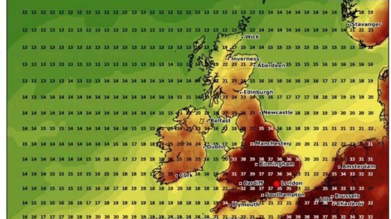
According to WXCharts’ latest weather maps, temperatures could approach a scorching 40°C on July 14 in some parts of the country. The forecast, which uses Met Desk data, highlights the West Midlands and South West England as potential hotspots, with temperatures possibly hitting 39°C. By 6 pm that day, even regions like Yorkshire and the Humber may see temperatures above 30°C.
The East Midlands and eastern England are also forecast to reach sweltering highs of 37–38°C, reports the Mirror. On July 14, both the South West and South East of England are likely to experience mid-to-high 30s, while London could peak at around 35°C.
Wales may see temperatures climb to 38°C in areas close to the English border. Meanwhile, Northern Ireland and Scotland are expected to remain cooler, with highs around 27°C, not exceeding 30°C.
July 14 is predicted to be the hottest day, but the warm spell is likely to last around a week, from July 11 to July 18, according to the weather maps.
The Met Office’s long-range forecast, covering July 9 to July 18, suggests a clear northwest-southeast split in weather patterns. The northwest is likely to see Atlantic fronts bringing rain, clouds, and breezy conditions, interspersed with some dry, bright periods. In contrast, the south and east should enjoy more dry, sunny weather under high pressure, with rising heat and humidity. Another bout of hot weather is expected around the second weekend of July and could continue into the following week. While the south will likely stay mostly dry, isolated thunderstorms remain possible.
Toward the end of July, warm conditions are expected to persist, with temperatures above average. The Met Office noted an increased chance of hot spells, especially in the southeast.
Looking into early August, forecasts suggest more unsettled weather could return across the UK. This comes after provisional Met Office data revealed that England had its hottest June on record, and the UK as a whole experienced its second warmest June since records began in 1884, following a very warm and sunny spring.
Met Office climate scientist Dr Amy Doherty stated: “Although we haven’t yet conducted formal studies on the June 2025 heatwaves, previous research shows it’s almost certain that human activity has intensified the frequency and severity of extreme heat events like these. Past attribution studies have confirmed that human influence increased the likelihood of events such as the 2018 summer and July 2022.”
She added that climate projections indicate hot spells will become more frequent in the future, particularly in the southeast, with rising temperatures expected year-round but peaking in summer.
In Nottingham, Accuweather forecasts temperatures between 31°C and 34°C next Friday and Saturday, with conditions gradually cooling through the week, along with sun, rain, and possible thunderstorms.


_2.jpg)

