With more than 200 flood warnings and alerts still in effect, Storm Bert is still wreaking havoc on towns throughout the United Kingdom.
Over the weekend, high winds and flooding caused homes in Wales to be submerged and roads to resemble rivers. Eluned Morgan, the first minister of Wales, described the storm as "absolutely devastating."
At least five deaths have been confirmed across England and Wales since Storm Bert hit. A body was found on Sunday in the search for a 75-year-old man missing in the River Conwy, as four others died in fatal motor-related incidents.
Severe travel disruption is also ongoing. Great Western Railway, which runs services between London and the West, has been forced to suspend many of its journeys - telling passengers to “not attempt to travel on any routes”.
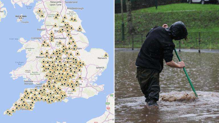
Here’s a map of current flood warnings and alerts in place across England and Wales:
In England, a severe flood warning has been issued for Billing Aquadrome and surrounding parks next to the River Nene in Northampton. Residents are advised this means there is a danger to life.
Two severe flood warnings previously issued for the River Monnow in south-east Wales for Monmouth and Skenfrith, have been lowered to warnings, meaning flooding is expected.
A further 175 flood warnings and 231 flood alerts are in place across England and Wales. Those affected by warnings are advised to act now, while people in areas where flood alerts have been issued should remain prepared.
In areas with severe flooding, it is recommended residents stay in a safe place away from the water. They should be ready to evacuate their homes, follow the instructions of emergency services and move to higher ground if caught in a flash flood.


.svg)


